使用HEC-HMS进行水文建模基础教程
需积分: 4 34 浏览量
更新于2024-07-09
1
收藏 331KB PDF 举报
"Hydrologic Modeling using HEC-HMS.pdf"
HEC-HMS(Hydrologic Engineering Center's Hydrologic Modeling System)是由美国陆军工程兵团开发的一款强大的水文学模拟工具,用于模拟流域的水文过程,包括降雨径流转换、洪水演算等。本教程由Venkatesh Merwade教授于2007年4月在普渡大学土木工程学院编撰,旨在介绍HEC-HMS的基本结构和功能,并通过模拟德克萨斯州奥斯汀的沃勒溪在设计风暴条件下的径流洪水图来学习其应用。
HEC-HMS的核心在于模拟降雨到径流的转化过程,这一过程涉及多个水文参数的计算,如蒸发、渗透、土壤含水量和地表径流等。教程中提到,沃勒溪的物理特性,如流域面积、地形、土地利用等,可预先使用GIS程序PrePro或HEC-GeoHMS进行处理。PrePro是一款由德克萨斯农工大学的F. Olivera教授提供的GIS工具,而HEC-GeoHMS则是集成在GIS平台ArcGIS中的预处理工具,两者都可以用于准备HEC-HMS所需的输入数据。
HEC-GeoHMS不仅提供了数据导入、地形分析、流域划分等功能,还简化了将地理空间数据转换为HEC-HMS模型输入的过程。对于HEC-GeoHMS的新版本,Merwade教授提供了一个在线教程,指导用户如何与最新版的ArcGIS协同使用。
在进行水文模型建立时,计算机需要安装最新的Windows操作系统,因为HEC-HMS可能依赖于特定的操作系统环境。此外,为了运行HEC-HMS和相关的GIS软件,计算机还需要满足软件的硬件配置要求,例如足够的内存、处理器速度和硬盘空间。
在本教程中,参与者将学习如何定义流域边界,估算关键水文参数,设置降雨事件,以及如何根据这些输入运行HEC-HMS模型来生成洪水曲线。这些技能对于理解和预测极端降雨事件对水系的影响至关重要,对于洪水风险管理、水资源规划和水文研究等领域具有很高的实用价值。通过实际操作,学习者可以加深对水文循环的理解,掌握使用HEC-HMS解决实际问题的能力。
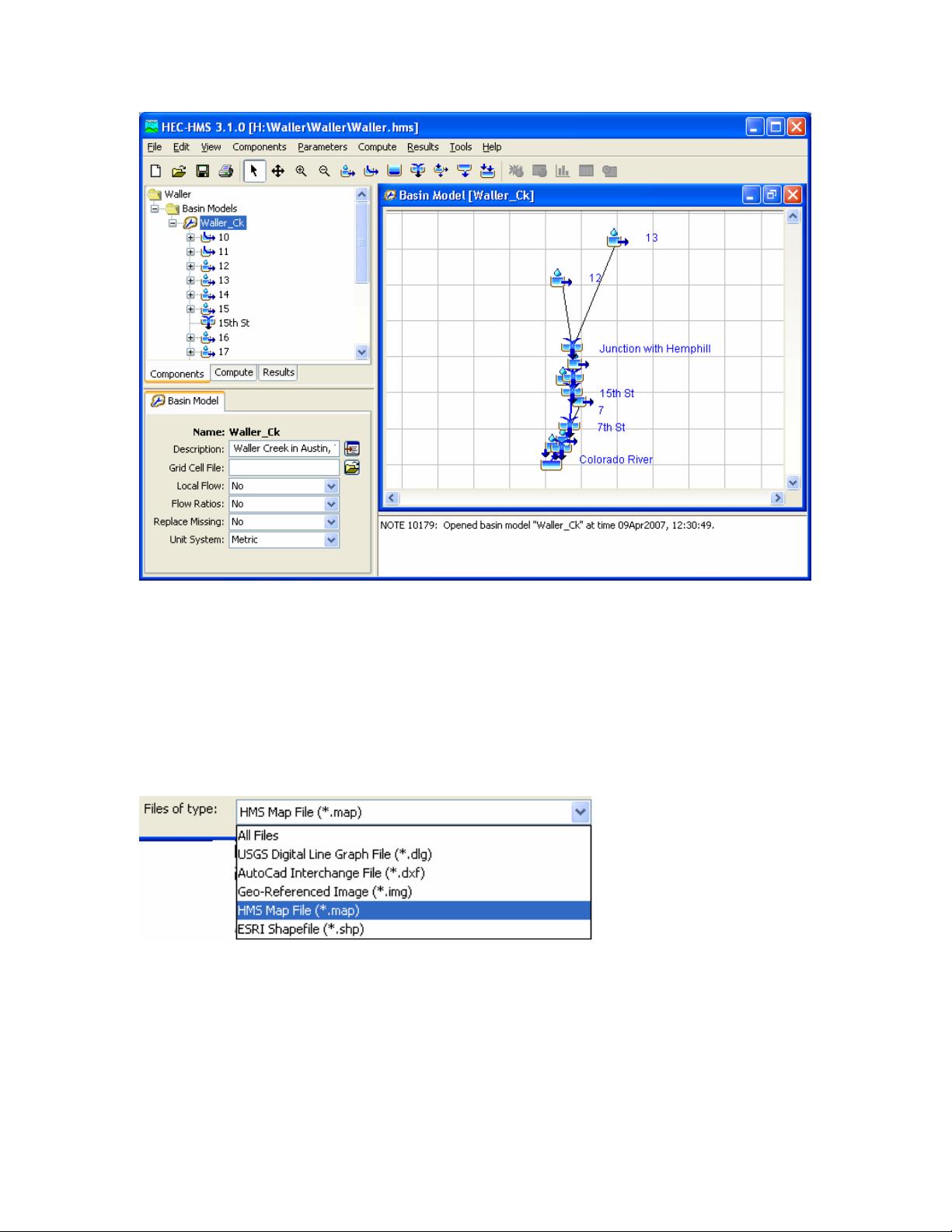
If you expand Waller_Ck, you will see different hydrologic elements in the basin in the
watershed explorer. Before we get into the details of the basin, go ahead and add the
basin map which is stored in the Hms.map file.
In the HMS interface, select ViewÆBackground Maps. This will prompt a Background
Maps window. In the Background Maps window, click on Add… Browse to the
Hms.map file in the working folder (make sure you change the Files of type to HMS Map
File (*.map) as shown below), and select it.
This will add Hms.map in the Background Maps window. Click OK to add it to the HMS
You should then see a schematic of Waller Creek showing the watershed and stream map
and an overlay of the hydrologic elements. You will notice that the whole map of the
basin does not fit in the Desktop window. You can change the Desktop settings by
selecting ViewÆMaximum Extents in the Menu bar. Select the display method as Union
of All Maps and Elements with an element buffer of 40 % or more as shown below:
4
剩余18页未读,继续阅读
1074 浏览量
344 浏览量
753 浏览量
2023-04-01 上传
2023-04-01 上传
214 浏览量
192 浏览量
1938 浏览量
2022-09-06 上传

你好菜鸟
- 粉丝: 7
- 资源: 5
 我的内容管理
展开
我的内容管理
展开


最新资源
- RPi-Flask-WebServer:带有Flask和Raspberry Pi的Python WebServer
- Portfolio-landing-page-2020:Epicodus独立项目。 个人投资组合登陆页面
- Test
- imersao-dev:Evento“ImersãoDev”,produzido pela Alura,com peequenos projetospráticosem JavaScript
- netflix.rar
- 斯科茨
- Python编写的爬虫程序
- Sense2021可用.zip
- BigCloneEval:BigCloneEval-BigCloneBench的克隆检测工具评估框架
- 迈德克斯摄像头驱动.zip
- algorithmx-python:网络可视化和算法仿真的库
- 7th Toolbar Spacer-crx插件
- oauth2-django
- webgis之OpenLayers地图使用教程合集_极品.zip
- MOOC网站上的《Python语言程序设计》课程对应练习、测验。题目引用自MOOC,代码均为自己编写。.zip
- memwatch.tar.gz
