厘米级城市多传感器融合定位系统:Apollo论文详解
本文档标题"apollo传感器融合论文.pdf"聚焦于自动驾驶领域中关键的传感器融合技术,特别是针对多场景下的车辆精确定位。作者Guowei Wan、Xiaolong Yang等人提出了一种创新且稳健的系统,旨在实现厘米级的定位精度,即使在城市市区、高速公路和隧道等复杂环境中也能保持高精度和鲁棒性。
论文的核心内容强调了系统如何有效地利用互补传感器数据,如全球导航卫星系统(GNSS)、激光雷达(LiDAR)和惯性测量单元(IMU)。传统上,LiDAR主要用于提供三维几何信息,但论文中提出了一种创新方法,即不仅依赖于LiDAR强度和三维数据,还利用LiDAR的强度和高度信息,显著提升了定位系统的准确性和抗干扰能力。
特别地,论文中的GNSS实时差分(RTK)模块利用了多传感器融合框架的优势,提高了模糊度解算的成功率。为了整合来自不同源的定位测量,文中采用了误差状态卡尔曼滤波器,其对不确定性进行了新颖的估计。通过详细的实验证明,该方法在各种场景下都能达到5-10厘米的根均方误差(RMS),明显优于现有的同类技术。
这篇论文深入探讨了自动驾驶系统中传感器融合的重要性,展示了如何通过巧妙地结合多种传感器的数据,克服环境挑战,提升车辆定位的精度和鲁棒性。这对于自动驾驶技术的发展具有重要意义,因为它确保了车辆在复杂环境下的稳定运行和安全性。此外,论文的实施方法和技术对于其他自动驾驶平台优化定位性能也有很高的参考价值。
Robust and Precise Vehicle Localization based on Multi-sensor Fusion
in Diverse City Scenes
Guowei Wan, Xiaolong Yang, Renlan Cai, Hao Li, Yao Zhou, Hao Wang, Shiyu Song
1
Abstract— We present a robust and precise localization
system that achieves centimeter-level localization accuracy in
disparate city scenes. Our system adaptively uses information
from complementary sensors such as GNSS, LiDAR, and
IMU to achieve high localization accuracy and resilience in
challenging scenes, such as urban downtown, highways, and
tunnels. Rather than relying only on LiDAR intensity or
3D geometry, we make innovative use of LiDAR intensity
and altitude cues to significantly improve localization system
accuracy and robustness. Our GNSS RTK module utilizes the
help of the multi-sensor fusion framework and achieves a better
ambiguity resolution success rate. An error-state Kalman filter
is applied to fuse the localization measurements from different
sources with novel uncertainty estimation. We validate, in detail,
the effectiveness of our approaches, achieving 5-10cm RMS
accuracy and outperforming previous state-of-the-art systems.
Importantly, our system, while deployed in a large autonomous
driving fleet, made our vehicles fully autonomous in crowded
city streets despite road construction that occurred from time to
time. A dataset including more than 60 km real traffic driving
in various urban roads is used to comprehensively test our
system.
I. INTRODUCTION
Vehicle localization is one of the fundamental tasks in
autonomous driving. The single-point positioning accuracy
of the global navigation satellite system (GNSS) is about
10m due to satellite orbit and clock errors, together with
tropospheric and ionospheric delays. These errors can be
calibrated out with observations from a surveyed reference
station. The carrier-phase based differential GNSS tech-
nique, known as Real Time Kinematic (RTK), can provide
centimeter positioning accuracy [1]. The most significant
advantage of RTK is that it provides almost all-weather
availability. However, its disadvantage is equally obvious
that it’s highly vulnerable to signal blockage, multi-path
because it relies on the precision carrier-phase positioning
techniques. Intuitively, LiDAR is a promising sensor for
precise localization. Failure during harsh weather conditions
and road construction still is an important issue of LiDAR-
based methods, although related works have shown good
progress in solving these problems, for example, light rain [2]
and snow [3]. Furthermore, LiDAR and RTK are two sensors
those are complementary in terms of applicable scenes.
LiDAR works well when the environment is full of 3D or
*This work is supported by Baidu Autonomous Driving Business Unit
in conjunction with the Apollo Project.
The authors are with Baidu Autonomous Driving Business Unit,
{wanguowei, yangxiaolong02, cairenlan, lihao30,
zhouyao, wanghao29, songshiyu}@baidu.com.
1
Author to whom correspondence should be addressed, E-mail:
songshiyu@baidu.com
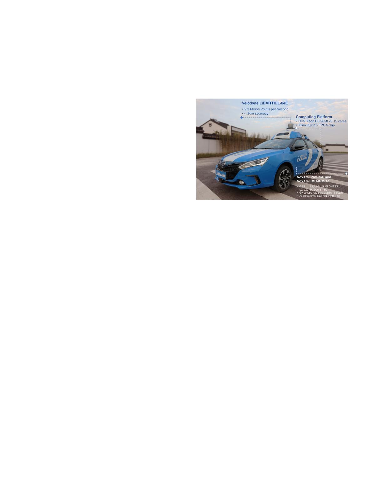
Fig. 1: Our autonomous vehicle is equipped with a Velodyne LiDAR HDL-
64E. An integrated navigation system, NovAtel ProPak6 plus NovAtel IMU-
IGM-A1, is installed for raw sensor data collection, such as GNSS pseudo
range and carrier wave, IMU specific force and rotation rate. The built-in
tightly integrated inertial and satellite navigation solution was not used. A
computing platform equipped with Dual Xeon E5-2658 v3 12 cores, and a
Xilinx KU115 FPGA chip with 55% utilization for LiDAR localization.
texture features, while RTK performs excellently in open
space. An inertial measurement unit (IMU), including the
gyroscopes and the accelerometers, continuously calculate
the position, orientation, and velocity via the technology
that is commonly referred to as dead reckoning. It’s self-
contained navigation method, that is immune to jamming
and deception. But it suffers badly from integration drift.
Thus, each sensor has its own unique characteristics and its
working conditions. Here, we propose a robust and precise
localization system using multi-sensor fusion designed for
autonomous vehicles driving in complex urban and highway
scenes. More precisely, we adaptively fuse different local-
ization methods based on sensors such as LiDAR, RTK, and
IMU. The sensor configuration of our system is shown in
Figure 1. Our system provides stable, resilient and precise lo-
calization service to other modules in an autonomous vehicle,
which has the capability of driving in several complex scenes,
such as downtown, tunnels, tree-lined roads, parking garages,
and highways. We demonstrate large-scale localization using
over 60 km of data in dynamic urban and highway scenes.
In Figure 2, we show the architecture of our multi-sensor
fusion framework.
To summarize, our main contributions are:
• A joint framework for vehicle localization that adap-
tively fuses different sensors including LiDAR, RTK,
and IMU. It effectively leverages their advantages and
shields our system from their failure in various scenes
下载后可阅读完整内容,剩余7页未读,立即下载
391 浏览量
618 浏览量
662 浏览量
198 浏览量
131 浏览量
266 浏览量
205 浏览量
368 浏览量

LEO爱排骨
- 粉丝: 14
 我的内容管理
展开
我的内容管理
展开


最新资源
- VB通过Modbus协议控制三菱PLC通讯实操指南
- simfinapi:R语言中简化SimFin数据获取与分析的包
- LabVIEW温度控制上位机程序开发指南
- 西门子工业网络通信实例解析与CP243-1应用
- 清华紫光全能王V9.1软件深度体验与功能解析
- VB实现Access数据库数据同步操作指南
- VB实现MSChart绘制实时监控曲线
- VC6.0通过实例深入访问Excel文件技巧
- 自动机可视化工具:编程语言与正则表达式的图形化解释
- 赛义德·莫比尼:揭秘其开创性技术成果
- 微信小程序开发教程:如何实现模仿ofo共享单车应用
- TrueTable在Windows10 64位及CAD2007中的完美适配
- 图解Win7搭建IIS7+PHP+MySQL+phpMyAdmin教程
- C#与LabVIEW联合采集NI设备的电压电流信号并创建Excel文件
- LP1800-3最小系统官方资料压缩包
- Linksys WUSB54GG无线网卡驱动程序下载指南
