
C# 使用使用GDI绘制雷达图的实例绘制雷达图的实例
主要介绍了C# 使用GDI绘制雷达图,本文通过一段实例代码给大家介绍的非常详细,具有一定的参考借鉴价值,
需要的朋友可以参考下
最近项目要用C#实现画一个雷达图,搜了搜网上竟然找不到C#画雷达图的解决方案,那么自己实现一个吧
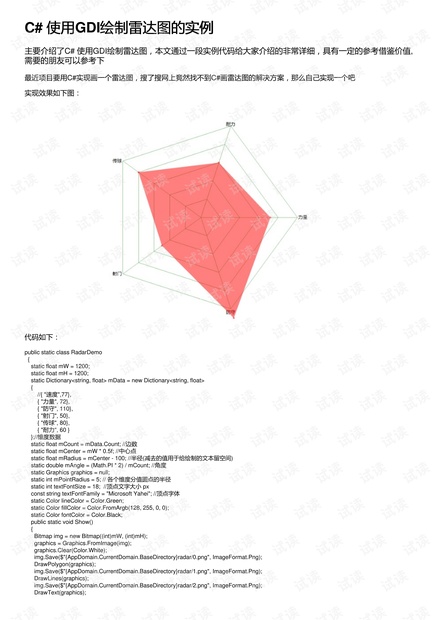
实现效果如下图:
代码如下:
public static class RadarDemo
{
static float mW = 1200;
static float mH = 1200;
static Dictionary<string, float> mData = new Dictionary<string, float>
{
//{ "速度",77},
{ "力量", 72},
{ "防守", 110},
{ "射门", 50},
{ "传球", 80},
{ "耐力", 60 }
};//维度数据
static float mCount = mData.Count; //边数
static float mCenter = mW * 0.5f; //中心点
static float mRadius = mCenter - 100; //半径(减去的值用于给绘制的文本留空间)
static double mAngle = (Math.PI * 2) / mCount; //角度
static Graphics graphics = null;
static int mPointRadius = 5; // 各个维度分值圆点的半径
static int textFontSize = 18; //顶点文字大小 px
const string textFontFamily = "Microsoft Yahei"; //顶点字体
static Color lineColor = Color.Green;
static Color fillColor = Color.FromArgb(128, 255, 0, 0);
static Color fontColor = Color.Black;
public static void Show()
{
Bitmap img = new Bitmap((int)mW, (int)mH);
graphics = Graphics.FromImage(img);
graphics.Clear(Color.White);
img.Save($"{AppDomain.CurrentDomain.BaseDirectory}radar/0.png", ImageFormat.Png);
DrawPolygon(graphics);
img.Save($"{AppDomain.CurrentDomain.BaseDirectory}radar/1.png", ImageFormat.Png);
DrawLines(graphics);
img.Save($"{AppDomain.CurrentDomain.BaseDirectory}radar/2.png", ImageFormat.Png);
DrawText(graphics);

weixin_38611459
- 粉丝: 6
- 资源: 917
 我的内容管理
收起
我的内容管理
收起
- 我的资源
快来上传第一个资源
 我的收益 登录查看自己的收益
 我的积分
登录查看自己的积分
我的积分
登录查看自己的积分
 我的C币
登录后查看C币余额
我的C币
登录后查看C币余额
 我的收藏
我的收藏  我的下载
我的下载  下载帮助
下载帮助

会员权益专享


最新资源
- zigbee-cluster-library-specification
- JSBSim Reference Manual
- c++校园超市商品信息管理系统课程设计说明书(含源代码) (2).pdf
- 建筑供配电系统相关课件.pptx
- 企业管理规章制度及管理模式.doc
- vb打开摄像头.doc
- 云计算-可信计算中认证协议改进方案.pdf
- [详细完整版]单片机编程4.ppt
- c语言常用算法.pdf
- c++经典程序代码大全.pdf
- 单片机数字时钟资料.doc
- 11项目管理前沿1.0.pptx
- 基于ssm的“魅力”繁峙宣传网站的设计与实现论文.doc
- 智慧交通综合解决方案.pptx
- 建筑防潮设计-PowerPointPresentati.pptx
- SPC统计过程控制程序.pptx
资源上传下载、课程学习等过程中有任何疑问或建议,欢迎提出宝贵意见哦~我们会及时处理!
点击此处反馈


评论0