Python空间数据分析入门与应用
"Spatial Data Analysis with Python 通过使用Python进行空间数据的处理和分析,以解决特定领域的问题。工作坊的目标包括了解ArcGIS中的批量处理、掌握Python脚本语言及其在ArcGIS中的应用、熟悉编写和运行地理处理脚本的方法、运用Python自动化GIS工作流程以及用Python解决自己的领域问题。"
在Python的空间数据分析中,主要涉及两种基本数据类型:矢量数据和栅格数据。矢量数据通常包括点、线和多边形,用于表示地理特征的精确边界和位置。而栅格数据则表示连续(如海拔)或离散(如土地利用类型)的表面,通常以像素矩阵的形式存在。常见的矢量数据存储格式有Shapefile、Geodatabase的特征表以及.dbf、.xlsx、KML和GeoJSON等。栅格数据的常见格式有ASCII、GeoTIFF和JPEG2000。
空间数据的重要性在于其能够捕捉到地理现象之间的关系和模式。例如,在确定城市房价时,可以考虑的地理变量包括距离市中心的距离、交通便利性、周边设施、环境质量等。这些变量都与地理位置密切相关,因此理解它们的空间分布对房价模型的构建至关重要。
Geographically Weighted Regression(GWR,地理加权回归)是一种用于建模空间变化关系的局部线性回归方法。在研究房价问题时,GWR允许我们分析不同地点的房价与影响因素之间的关系可能存在的空间差异。例如,同一影响因素(如学校质量)对不同地区的房价影响可能因位置的不同而有所变化。通过GWR,我们可以得到更加精细化的模型,揭示这些空间变异性的模式。
Python在空间分析中的应用广泛,可以用于数据预处理、数据可视化、空间统计分析和模型构建等多个环节。通过学习和掌握Python脚本,用户能够高效地自动化复杂的GIS任务,提高工作效率。例如,可以编写脚本来批量转换数据格式、提取特定区域的信息、执行缓冲区分析、计算空间统计指标等。此外,Python还支持众多库,如GDAL/OGR用于读写多种空间数据格式,NumPy和Pandas提供强大的数组和表格操作,Matplotlib和Plotly用于绘制美观的图形,而geopandas和shapely则简化了空间数据的操作和几何对象的处理。
"Spatial Data analysis python"的工作坊旨在帮助参与者掌握Python在GIS领域的应用,通过实践和讨论,解决实际问题,提升空间分析能力。无论是进行地理加权回归还是其他空间统计分析,Python都提供了强大的工具和框架,使得空间数据的探索和解释变得更加便捷和深入。
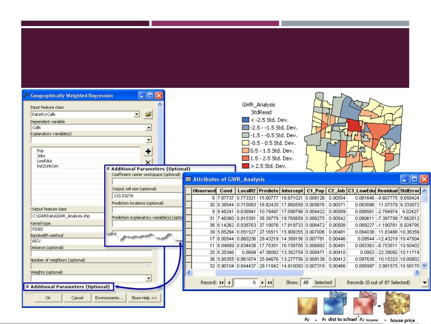
Geographically Weighted Regression (GWR)
剩余34页未读,继续阅读
2019-09-18 上传
2017-12-30 上传
2021-05-04 上传
2021-05-19 上传
2021-05-12 上传
140 浏览量
2018-05-10 上传
2015-12-17 上传

bai_yicn
- 粉丝: 0
- 资源: 4
 我的内容管理
展开
我的内容管理
展开


最新资源
- JavaScript实现的高效pomodoro时钟教程
- CMake 3.25.3版本发布:程序员必备构建工具
- 直流无刷电机控制技术项目源码集合
- Ak Kamal电子安全客户端加载器-CRX插件介绍
- 揭露流氓软件:月息背后的秘密
- 京东自动抢购茅台脚本指南:如何设置eid与fp参数
- 动态格式化Matlab轴刻度标签 - ticklabelformat实用教程
- DSTUHack2021后端接口与Go语言实现解析
- CMake 3.25.2版本Linux软件包发布
- Node.js网络数据抓取技术深入解析
- QRSorteios-crx扩展:优化税务文件扫描流程
- 掌握JavaScript中的算法技巧
- Rails+React打造MF员工租房解决方案
- Utsanjan:自学成才的UI/UX设计师与技术博客作者
- CMake 3.25.2版本发布,支持Windows x86_64架构
- AR_RENTAL平台:HTML技术在增强现实领域的应用
