S57 Map Introduction: Understanding the S57 Format and Its Importance in Chart Making
发布时间: 2024-09-14 14:14:50 阅读量: 31 订阅数: 35 
# 1. What is the S57 Map Format?
- **Definition of S57 Format**
- **Characteristics of S57 Format**
# 2. Application of S57 Format in Chart Production
- **History of S57 Format**
The S57 format is a data exchange format for electronic charts established by the International Maritime Organization (IMO). Initially released in 1992, it aims to provide a standardized way to store chart data so that Electronic Navigational Charts (ENC) can be used by various electronic navigation systems.
- **Relationship Between S57 Format and ENC**
The S57 format is the foundation of ENC, establishing a standard for the storage structure and feature classification of chart data. ENC, on the other hand, is an electronic chart made on the basis of S57 format for use on ships.
- **Advantages of S57 Format**
The S57 format adopts an object-oriented data model, allowing for flexible storage of various chart element information, including depth, buoys, and shipping lanes. Moreover, the data structure of S57 is clear and easy to parse and process, facilitating data editing and updating for chart makers.
# 3. Data Structure of S57 Maps
The data structure of S57 maps refers to the organization, classification, and attributes of its internal data. The following will detail the structure of S57 map data:
#### 3.1 Organization of S57 Map Data
S57 map data utilizes an object-based data model, with data stored in a database as objects. Each object has a unique identifier and attributes, and objects are connected through associations, which can be one-to-one, one-to-many, or many-to-many.
#### 3.2 Classification of S57 Map Data
S57 map data is classified and stored according to different feature types, mainly including various nautical chart elements such as depth, rocks, light beacons, navigation buoys, shipping lanes, ports, etc. Each feature type has corresponding attribute information, such as name, coordinates, shape, etc.
#### 3.3 Attributes of S57 Map Data
The attributes of S57 map data include basic information, geometric information, and semantic information of features. Basic information includes the feature's unique identifier, name, type, etc.; geometric information describes the feature's spatial location and shape; semantic information defines the feature's meaning and characteristics.
When processing S57 map data, proper parsing and handling of these attributes are necessary for the display and analysis of the map.
# 4. S57 Chart Production Process
The production of S57 charts generally involves the following steps:
1. **Data Collection**: Obtain data related to the ocean or waters through various measuring means, including depth, terrain, rocks, navigation buoys, etc.
```python
# Sample code: Data Collection
def data_collection():
# Conduct marine surveys
# Obtain data such as depth and terrain
# Collect information on navigation buoys, rocks, etc.
print("Data collection completed")
```
2. **Data Processing and Editing**: Process and edit the collected data, including cleaning data, correcting errors, adding missing information, etc.
```python
# Sample code: Data Processing and Editing
def data_processing_editing():
# Clean data, remove invalid information
# Correct errors in the data
# Add missing information
print("Data processing and editing completed")
```
3. **Data Conversion and Export**: Convert the processed and edited data into S57 format and export it as the final S57 map file.
```python
# Sample code: Data Conversion and Export
def data_conversion_export():
# Convert data into S57 format
# Export S57 map file
print("Data conversion and export completed")
```
By following the above process, we can complete the production of S57 charts, ensuring the accuracy and completeness of the chart data.
# 5. Standardization and Update of S57 Format
As the standard for electronic chart data, the standardization and updating of the S57 format are particularly important. In this chapter, we will explore the standard-setting body, the update mechanism, and the future development trend of the S57 standard.
#### Standard-Setting Body of S57 Standard
The S57 standard is established and managed by the International Hydrographic Organization (IHO). As an authoritative organization in the global maritime field, IHO is responsible for the formulation and updating of various chart standards, including the electronic chart standard S57.
#### Update Mechanism of S57 Standard
The update of the S57 standard follows the guiding principles and procedures of the IHO. Generally, the IHO will regularly evaluate the S57 standard, collect user feedback and technical requirements, and update and revise it based on actual needs. This ensures that the S57 standard remains synchronized with technological advancements and industry needs.
#### Future Development Trend of S57 Standard
With the continuous progress of technology and the development of the maritime industry, the S57 standard is also evolving. In the future, the S57 standard may focus more on the accuracy, real-time, and reliability of data, while achieving better interoperability with other standards and systems, providing more convenient and secure data support for the maritime field.
In the next chapter, we will discuss in detail the importance of the S57 format in chart production.
# 6. Importance of S57 Format in Chart Production
The S57 format plays a crucial role in chart production, playing an indispensable role in maritime safety, voyage planning, and maritime management.
#### Relationship Between S57 Format and Maritime Safety
The use of the S57 format can ensure the accuracy and consistency of chart data, ensuring that navigators can navigate based on the latest and most reliable data. Any errors or inconsistencies could lead to maritime accidents, and the standardization and norms of the S57 format can improve the level of maritime safety to some extent.
```python
# Sample code
def check_safety(s57_data):
# Perform a safety check on the chart data
if s57_data.quality_check():
return "Chart data is safe and meets S57 format standards"
else:
return "Chart data has issues that may affect maritime safety"
```
**Code Summary**: The above code demonstrates how to check the safety of S57 format chart data, ensuring that the data meets standards through quality checks.
**Result Explanation**: If the chart data meets the S57 format standard, a message indicating that the safety check has passed is returned; otherwise, a warning message indicating potential issues is returned.
#### Role of S57 Format in Voyage Planning
Voyage planning relies on accurate chart data, and the S57 format can provide rich information on shipping lanes, buoys, lighthouses, etc., helping planners effectively plan routes, avoid obstacles, choose the best routes, and ensure the safe arrival of vessels at their destination.
```java
// Sample Java code
public void plan_voyage(S57Data s57_data) {
Route optimal_route = s57_data.find_optimal_route();
VoyagePlan voyage_plan = new VoyagePlan(optimal_route);
voyage_plan.display();
}
```
**Code Summary**: The above Java code shows the process of planning a voyage route based on S57 format chart data and displays the information of the voyage plan.
**Result Explanation**: Voyage planners can use S57 format data to find the best route and generate a voyage plan for actual navigation.
#### Application of S57 Format in Maritime Management
Maritime management departments use S57 format chart data for maritime regulation, vessel management, and marine environmental protection. Accurate chart data can support maritime management departments in better managing marine resources, monitoring navigation safety, and protecting the marine environment.
```go
// Sample Go code
func maritime_management(s57_data S57Data) {
incidents := s57_data.identify_incidents()
for _, incident := range incidents {
incident.handle()
}
}
```
**Code Summary**: The above Go code demonstrates how to use S57 format chart data to identify maritime incidents and handle them.
**Result Explanation**: Maritime management departments can promptly detect and address maritime incidents, maintaining maritime order and navigation safety.

 百万级
高质量VIP文章无限畅学
百万级
高质量VIP文章无限畅学
 千万级
优质资源任意下载
千万级
优质资源任意下载
 C知道
免费提问 ( 生成式Al产品 )
C知道
免费提问 ( 生成式Al产品 )
0
0
相关推荐

专栏目录
最低0.47元/天 解锁专栏
买1年送3月
百万级
高质量VIP文章无限畅学
千万级
优质资源任意下载
C知道
免费提问 ( 生成式Al产品 )
最新推荐
深入解析MODBUS RTU模式:构建工业通信环境的不二选择

# 摘要
本文旨在全面介绍MODBUS RTU模式的各个方面,包括其基础通信协议、实践应用以及与现代技术的融合。首先,概述了MODBUS RTU模式,并详细解析了其数据格式、错误检测机制以及指令集。然后,分析了MODBUS RTU在工业控制领域的应用,涵盖了设备间数据交互、故障诊断和通信环境的搭建与优化。此外,探讨了MODBUS RTU与TCP/IP的桥接技术
【从零开始到MySQL权限专家】:逐层破解ERROR 1045的终极方案

# 摘要
本文旨在深入探讨MySQL权限系统及与之相关的ERROR 1045错误。首先,我们解释了MySQL权限系统的基本概念及其在数据库管理中的作用。随后,文章详细分析了ERROR 1045错误的多种产生原因,例如密码、用户名错误及权限配置问题,并探讨了该错误对数据库访问、操作和安全性的影响。在理论分
【解锁编码转换秘籍】:彻底搞懂UTF-8与GB2312的互换技巧(专家级指南)
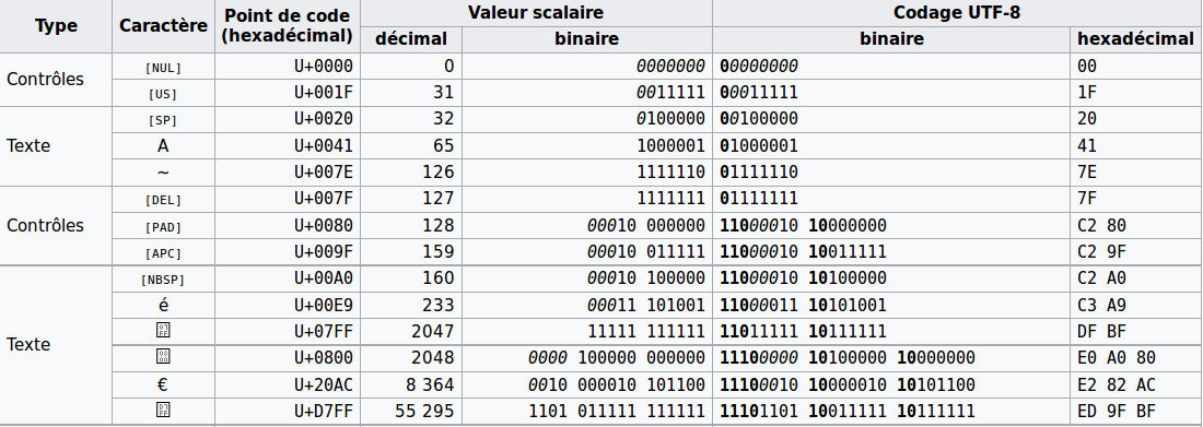
# 摘要
本文全面探讨了编码转换的必要性、基础概念,以及UTF-8与GB2312编码的转换技术。文章首先介绍了编码转换的基本原理与重要性,接着深入解析UTF-8编码的机制及其在不同编程环境中的应用和常见问题。接着,文章转向GB2312编码,讨论其历史背景、实践应用以及面临的挑战。之后,文章详细介绍了UTF-8与GB2312之间转换的技巧、实践和常见
【性能调优全解析】:数控机床PLC梯形图逻辑优化与效率提升手册
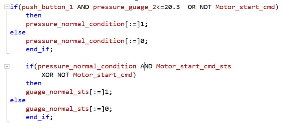
# 摘要
本文首先介绍了数控机床与PLC梯形图的基础知识,随后深入探讨了PLC梯形图的逻辑设计原则和优化理论。文中详细阐述了逻辑优化的目的和常用技术,并提供了优化步骤与方法,以及实际案例分析。接着,本文聚焦于PLC梯形图效率提升的实践,包括程序结构优化、高速处理器与存储技术的应用,以及硬件升级的最佳实践。文章最后对性能监控与故障诊断的重要性
揭秘流量高峰期:网络流量分析的终极技巧

# 摘要
随着网络技术的迅速发展,网络流量分析在确保网络安全和提升网络性能方面发挥着越来越重要的作用。本文首先概述网络流量分析的基本概念和重要性,随后深入探讨了数据采集和预处理的技术细节,包括使用的工具与方法,以及对数据进行清洗、格式化和特征提取的重要性。理论与方法章节详细介绍了网络流量的基本理论模型、行为分析、异常检测技术和流量预测模型。实践技巧章节提供了实时监
VCO博士揭秘:如何将实验室成果成功推向市场

# 摘要
本文全面探讨了实验室成果商业化的理论基础和实际操作流程。首先,分析了技术转移的策略、时机和对象,以及知识产权的种类、重要性及其申请与维护方法。接着,阐述了产品开发中的市场定位、竞争优势以及开发计划的重要性,并对市场趋势进行了深入的风险评估。文章还介绍了融资策略和商业模型构建的关键点,包括价值主张、成本结构和财务规划。最后,通过成功与失败案例的分析,总结了商业化过程中的经验教训,并对未来科技与市场趋势进行了展望,为
C2000 InstaSPIN FOC优化指南:三电阻采样策略的终极优化技巧

# 摘要
本文全面介绍了C2000 InstaSPIN-FOC技术及其在三电阻采样策略中的应用。首先,概述了InstaSPIN-FOC技术的基础,并探讨了三电阻采样原理的优势及应用场景。接着,通过硬件设计要点的分析,阐述了如何在采样精度与系统成本之间取得平衡。软件实现部分详细说明了在C2000平台上进行三电阻采样初始化、算法编码以及数据处理的关键步骤。文章还探讨了优化三电阻采样
Go语言Web并发处理秘籍:高效管理并发请求

# 摘要
Go语言以其简洁的并发模型和高效的goroutine处理机制在Web开发领域中受到广泛关注。本文首先概述了Go语言Web并发处理的基本原理,随后深入探讨了goroutine的并发模型、最佳实践以及goroutine与通道的高效互动。在Web请求处理方面,本文详细介绍了如何通过goroutine模式
隐藏节点无处藏身:载波侦听技术的应对策略

# 摘要
载波侦听多路访问(CSMA)技术是无线网络通信中的重要组成部分。本文首先概述了CSMA技术,继而探讨其理论基础,重点分析了隐藏节点问题的产生
Paho MQTT性能优化:减少消息延迟的实践技巧

# 摘要
本文深入探讨了基于Paho MQTT协议的延迟问题及其性能优化策略。首先介绍了MQTT的基础知识和消息传输机制,强调了发布/订阅模型和消息传输流程的重要性。接着,文章分析了MQTT延迟的根本原因,包括网络延迟和服务质量(QoS)的影响。为了缓解延迟问题,本文提出了针
资源上传下载、课程学习等过程中有任何疑问或建议,欢迎提出宝贵意见哦~我们会及时处理!
点击此处反馈


专栏目录
最低0.47元/天 解锁专栏
买1年送3月
百万级
高质量VIP文章无限畅学
千万级
优质资源任意下载
C知道
免费提问 ( 生成式Al产品 )