OSGEarth Layer Management: Creating, Editing, and Displaying Layers
发布时间: 2024-09-14 14:18:07 阅读量: 41 订阅数: 35 
# 1. Introduction to OSGEarth Layer Management
- What is OSGEarth Layer Management
- Applications of OSGEarth in Geographic Information Systems
# 2. **Overview of Layer Management Tools**
OSGEarth offers a variety of layer management tools to facilitate users' management and manipulation of map layers.
1. **LayerTool**
- Used for adding, editing, and removing layers.
- Supports setting layers to display or hide.
- Example code:
```python
from osgEarth import LayerTool
tool = LayerTool()
layer = tool.addLayer("roads.tif")
tool.removeLayer(layer)
```
2. **LayerStyleTool**
- Used for configuring layer styles, including color, line type, etc.
- Example code:
```python
from osgEarth import LayerStyleTool
style_tool = LayerStyleTool()
style_tool.setFillColor(layer, [0.5, 0.5, 0.5, 1.0])
```
3. **LayerOrderTool**
- Used for adjusting the stacking order of layers.
- Example code:
```python
from osgEarth import LayerOrderTool
order_tool = LayerOrderTool()
order_tool.raiseLayer(layer)
```
4. **LayerOpacityTool**
- Used for adjusting the opacity of layers.
- Example code:
```python
from osgEarth import LayerOpacityTool
opacity_tool = LayerOpacityTool()
opacity_tool.setOpacity(layer, 0.5)
```
With these tools, users can conveniently add, edit, style, and control the display of map layers, enhancing the efficiency and flexibility of layer management.
# 3. Creating Layers
Creating layers in OSGEarth is a common operation that can be easily accomplished through the following steps:
1. **Steps:**
- **Import necessary libraries and modules**
- **Create a layer object**
- **Set layer properties**
- **Add data sources**
2. **Considerations:**
- **Ensure layer types match data source types**
- **Check if layer coordinate systems are consistent with map coordinate systems**
- **Follow naming conventions for easier subsequent management**
3. **Supported Layer Types:**
- **Vector Layer (VectorLayer): Used for displaying vector data such as points, lines, and polygons**
- **Raster Layer (ImageLayer): Used for di

 百万级
高质量VIP文章无限畅学
百万级
高质量VIP文章无限畅学
 千万级
优质资源任意下载
千万级
优质资源任意下载
 C知道
免费提问 ( 生成式Al产品 )
C知道
免费提问 ( 生成式Al产品 )
0
0
相关推荐

专栏目录
最低0.47元/天 解锁专栏
买1年送3月
百万级
高质量VIP文章无限畅学
千万级
优质资源任意下载
C知道
免费提问 ( 生成式Al产品 )
最新推荐
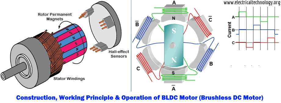
JY01A直流无刷IC全攻略:深入理解与高效应用
# 摘要
本文详细介绍了JY01A直流无刷IC的设计、功能和应用。文章首先概述了直流无刷电机的工作原理及其关键参数,随后探讨了JY01A IC的功能特点以及与电机集成的应用。在实践操作方面,本文讲解了JY01A IC的硬件连接、编程控制,并通过具体
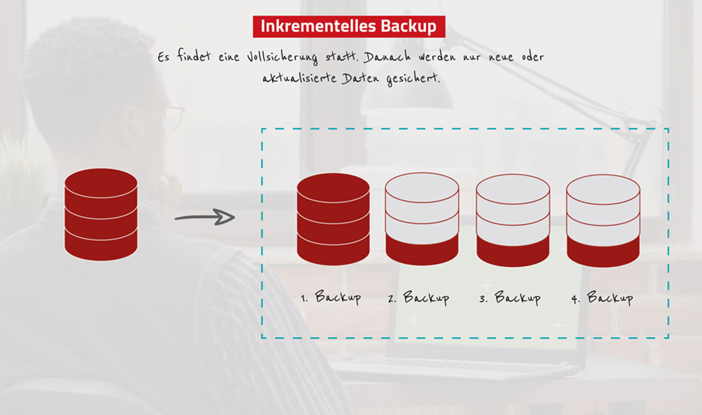
数据备份与恢复:中控BS架构考勤系统的策略与实施指南
# 摘要
在数字化时代,数据备份与恢复已成为保障企业信息系统稳定运行的重要组成部分。本文从理论基础和实践操作两个方面对中控BS架构考勤系统的数据备份与恢复进行深入探讨。文中首先阐述了数据备份的必要性及其对业务连续性的影响,进而详细介绍了不同备份类型的选择和备份周期的制定。随后,文章深入解析了数据恢复的原理与流程,并通过具体案例分析展示了恢复技术的实际应用。接着,本文探讨
【TongWeb7负载均衡秘笈】:确保请求高效分发的策略与实施
.webp)
# 摘要
本文从基础概念出发,对负载均衡进行了全面的分析和阐述。首先介绍了负载均衡的基本原理,然后详细探讨了不同的负载均衡策略及其算法,包括轮询、加权轮询、最少连接、加权最少连接、响应时间和动态调度算法。接着,文章着重解析了TongWeb7负载均衡技术的架构、安装配置、高级特性和应用案例。在实施案例部分,分析了高并发Web服务和云服务环境下负载
【Delphi性能调优】:加速进度条响应速度的10项策略分析

# 摘要
本论文首先概述了信号定位技术的基本概念和重要性,随后深入分析了三角测量和指纹定位两种主要技术的工作原理、实际应用以及各自的优势与不足。通过对三角测量定位模型的解析,我们了解到其理论基础、精度影响因素以及算法优化策略。指纹定位技术部分,则侧重于其理论框架、实际操作方法和应用场
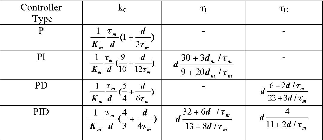
【PID调试实战】:现场调校专家教你如何做到精准控制
# 摘要
PID控制作为一种历史悠久的控制理论,一直广泛应用于工业自动化领域中。本文从基础理论讲起,详细分析了PID参数的理论分析与选择、调试实践技巧,并探讨了PID控制在多变量、模糊逻辑以及网络化和智能化方面的高级应用。通过案例分析,文章展示了PID控制在实际工业环境中的应用效果以及特殊环境下参数调整的策略。文章最后展望了PID控制技术的发展方
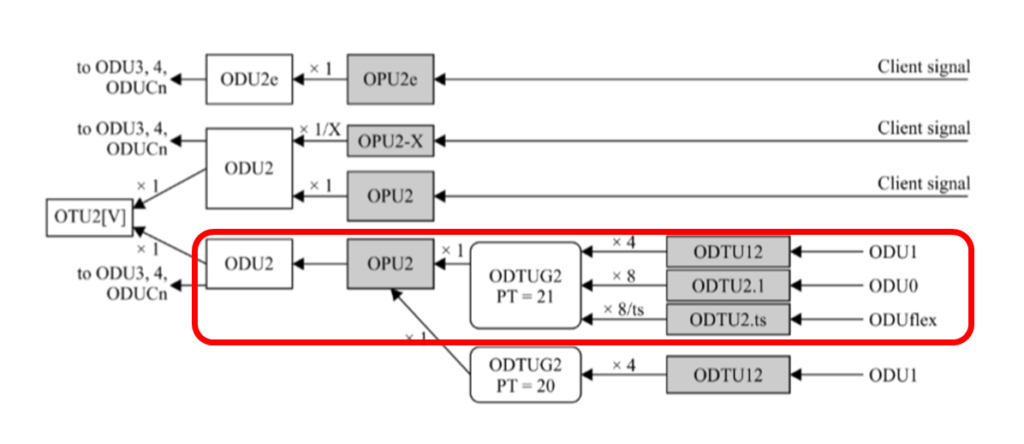
网络同步新境界:掌握G.7044标准中的ODU flex同步技术
# 摘要
本文详细探讨了G.7044标准与ODU flex同步技术,首先介绍了该标准的技术原理,包括时钟同步的基础知识、G.7044标准框架及其起源与应用背景,以及ODU flex技术
字符串插入操作实战:insert函数的编写与优化
# 摘要
字符串插入操作是编程中常见且基础的任务,其效率直接影响程序的性能和可维护性。本文系统地探讨了字符串插入操作的理论基础、insert函数的编写原理、使用实践以及性能优化。首先,概述了insert函数的基本结构、关键算法和代码实现。接着,分析了在不同编程语言中insert函数的应用实践,并通过性能测试揭示了各种实现的差异。此外,本文还探讨了性能优化策略,包括内存使用和CPU效率提升,并介绍了高级数据结
环形菜单的兼容性处理

# 摘要
环形菜单作为一种用户界面元素,为软件和网页设计提供了新的交互体验。本文首先介绍了环形菜单的基本知识和设计理念,重点探讨了其通过HTML、CSS和JavaScript技术实现的方法和原理。然后,针对浏览器兼容性问题,提出了有效的解决方案,并讨论了如何通过测试和优化提升环形菜单的性能和用户体验。本
资源上传下载、课程学习等过程中有任何疑问或建议,欢迎提出宝贵意见哦~我们会及时处理!
点击此处反馈


专栏目录
最低0.47元/天 解锁专栏
买1年送3月
百万级
高质量VIP文章无限畅学
千万级
优质资源任意下载
C知道
免费提问 ( 生成式Al产品 )